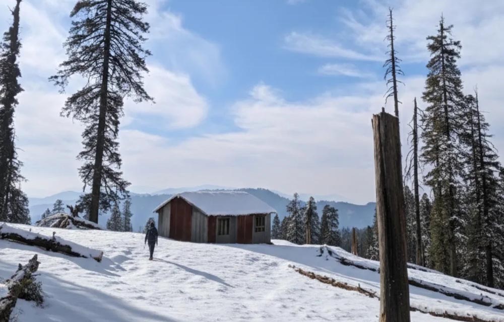
Doodhatoli, also spelled Dudhatoli or Doodhatoli, is one of the lesser-known highland landscapes of Uttarakhand. Far from the crowded tourist centres that dominate Himalayan travel, this mountain region offers a remarkable combination of rolling alpine meadows, dense forests, snow-covered ridges, traditional pastoral life, mountain streams and expansive Himalayan views. Situated primarily across the Pauri Garhwal and Chamoli Garhwal areas, Doodhatoli is particularly appealing to travellers interested in trekking, nature, rural culture and quiet mountain experiences.
The region reaches elevations of around 3,100 metres, and its central highlands are characterised by broad ridges and meadows rather than the sharply pointed peaks associated with some other parts of the Himalayas. The District Pauri Garhwal administration describes Doodhatoli as a picturesque destination covered with dense mixed forest and notes its panoramic views of the Himalayan ranges.
Often described as the “Pamir of Uttarakhand,” Doodhatoli has a distinctive geographical character. Its gently undulating mountain terrain, extensive grasslands and relatively remote setting make it quite different from more commercialised hill stations. For visitors willing to undertake a trek, it provides an opportunity to experience a quieter side of Uttarakhand.
Where Is Doodhatoli?
Doodhatoli forms a mountain and forest range in the Middle Himalayas of Uttarakhand. The range extends through parts of Pauri Garhwal and Chamoli Garhwal, with its landscape encompassing high ridges, forests and pastoral meadows. The main range runs broadly north-south and is associated with areas around Thalisain, Gairsain and surrounding mountain settlements.
The name Doodhatoli is generally connected with the Garhwali expression “Doodh ki Tauli,” interpreted as a “cauldron of milk.” The name is traditionally associated with the area’s long history of cattle and livestock grazing. The lush mountain pastures supported large numbers of cattle, buffaloes, sheep and goats, and pastoral communities historically used temporary shelters in the highlands during the warmer months.
Today, the name provides an interesting insight into the relationship between the landscape and local livelihoods. Doodhatoli was not simply a wilderness landscape; its meadows were economically and culturally important to communities living in the surrounding valleys.
The Landscape and Geography of Doodhatoli
One of Doodhatoli’s most fascinating characteristics is its combination of forests and open grasslands. The higher portions contain expansive meadows, while lower and intermediate elevations are covered by mixed Himalayan forests. The core of the Doodhatoli mountains reaches approximately 2,900–3,000 metres, while the broader highland region rises to around 3,100 metres.
Unlike many Himalayan destinations where tourism revolves around a single summit, Doodhatoli is better understood as an extensive mountain landscape. Ridges, forest paths, meadows, springs and viewpoints form the experience. The scenery changes continuously as a trek progresses, with dense woodland giving way to open slopes and high pastures.
The range is also important from a hydrological perspective. Several streams and perennial rivers originate in or around the Doodhatoli highlands. The region contributes to the headwaters of river systems including the eastern and western Nayar and the western Ramganga. This makes the mountains important not only for scenery and trekking but also for water resources in surrounding valleys.
Snowfall during winter contributes additional moisture, while the monsoon replenishes springs and streams. In this way, the highlands act as an important natural water-storage and recharge landscape.
Why Is Doodhatoli Called the “Pamir of Uttarakhand”?
The comparison with the Pamir is primarily descriptive, reflecting Doodhatoli’s broad, rolling mountain terrain and extensive open highland landscapes. Instead of narrow valleys and dramatic rocky summits, visitors encounter expansive ridges and meadows that can create a feeling of openness.
This character is especially noticeable when walking through the higher reaches. The combination of grass-covered slopes, scattered trees, distant Himalayan peaks and changing cloud formations gives the landscape a distinctive visual identity.
The comparison should not be interpreted as suggesting that Doodhatoli has the same geography or altitude as the Pamir Mountains of Central Asia. It is better understood as a local geographical nickname highlighting the appearance and character of its highland terrain.
Forests and Flora
Doodhatoli’s forests are among its greatest natural attractions. Mixed Himalayan forests cover substantial parts of the mountain region, with oak, fir, deodar, maple and other temperate species occurring in different areas and elevations. The landscape also contains shrubs, wild fruits and medicinal plants traditionally used by local communities.
The forests can be particularly beautiful during periods of seasonal change. Oak-covered slopes create deep green landscapes during the warmer months, while rhododendrons add colour during their flowering season. Coniferous trees provide another characteristic feature of the higher mountain environment.
The plant diversity also has cultural significance. Mountain communities have traditionally depended on forests for fodder, fuel, wild foods and medicinal resources. Such relationships demonstrate why the protection of Doodhatoli’s forests is important beyond tourism.
Wildlife and Birdlife
Doodhatoli provides habitat for a variety of Himalayan wildlife. Reports about the region mention animals including leopard, jungle cat, Himalayan black bear, wild boar, ghoral, porcupine and hare. Numerous bird species also inhabit the forests and meadows, with pheasants among the notable birds associated with the area.
For wildlife enthusiasts, however, Doodhatoli should be approached as a natural habitat rather than a conventional wildlife-viewing destination. Animals are not guaranteed to appear, and responsible visitors should maintain distance, avoid disturbing wildlife and follow local guidance.
Birdwatching can be particularly rewarding because forest edges, meadows and high ridges provide different habitats. Early mornings are generally the most peaceful time for observing birds and listening to forest sounds.
Doodhatoli and Traditional Pastoral Life
Perhaps one of the most distinctive aspects of Doodhatoli is its connection with pastoral communities. Historically, the high-altitude grasslands were used for seasonal grazing. Herds were moved toward the higher pastures during warmer months and returned to lower settlements before the harsh winter.
Temporary structures known locally as khark or chhaanni were traditionally established in the grazing areas. Historical accounts describe very large numbers of cattle and buffalo being kept in temporary highland settlements, illustrating the economic importance of these meadows.
Although modern economic conditions have changed traditional pastoral practices, seasonal livestock movement remains part of the cultural memory and landscape of the region. A traveller walking through Doodhatoli may therefore encounter not only forests and mountains but also evidence of an older pastoral way of life.
This relationship between people, livestock, grasslands and forests is an important part of understanding Doodhatoli.
Trekking in Doodhatoli
Trekking is the principal way to experience Doodhatoli. It is not a destination where visitors simply drive to a central market and explore attractions around town. The journey itself is an important part of the experience.
The Pauri Garhwal administration identifies Doodhatoli as a trekking destination and describes a route beginning from Thalisain. According to the district’s tourism information, Thalisain is approximately 104 kilometres by road from Pauri, after which the Doodhatoli area is reached through trekking routes. One described itinerary approaches through Peersain and Binsar before continuing toward Doodhatoli.
Another commonly described approach is from the Gairsain side. The exact trek length can vary depending on the starting point and route chosen, so travellers should verify current trail conditions and local access before beginning.
The trek can involve forest trails, steep sections, uneven ground and changing weather. Consequently, Doodhatoli is better suited to travellers who are comfortable with mountain trekking than to those seeking an easy sightseeing excursion.
Binsar Mahadev and Nearby Attractions
The broader Doodhatoli region can be combined with other attractions in the surrounding Garhwal landscape. One important place is Binsar Mahadev Temple, located amid forested mountain surroundings. The temple is associated with local religious traditions and is an important cultural landmark in the area.
The District Pauri Garhwal tourism information includes Binsar-related trekking as part of the broader Doodhatoli adventure itinerary. The landscape around the temple contains forests and mountain trails, making it possible to combine nature, trekking and cultural exploration.
Travellers approaching from the Gairsain side can also explore the wider Gairsain area. Because Doodhatoli lies across a geographically broad mountain region rather than around a single tourist settlement, planning a trip around nearby villages, temples and viewpoints can make the journey more rewarding.
Weather and Best Time to Visit
Doodhatoli experiences a typical high-elevation Himalayan climate. Summers are comparatively pleasant, while winters are extremely cold. Snowfall can occur during winter, and the higher areas may remain snow-covered into early spring. Sources describing the region note significant snowfall between December and March and temperatures that can fall below freezing during winter.
Spring and early summer can be attractive for visitors interested in forests, flowering plants and comfortable trekking conditions. The monsoon season brings lush greenery but also creates challenges such as slippery trails, heavy rain, fog and possible landslides on mountain roads.
Autumn is often appealing for mountain views because skies can become clearer after the monsoon. The landscape can also have excellent visibility toward distant Himalayan ranges.
Winter is suitable for experienced travellers specifically interested in snow and winter landscapes, but conditions can be difficult. Snow, freezing temperatures and limited facilities mean that winter trekking requires significantly more preparation.
How to Reach Doodhatoli
Doodhatoli is deliberately less accessible than Uttarakhand’s major tourist centres. This limited accessibility is part of its attraction, but it also means that visitors need to plan carefully.
One principal approach is through Thalisain in Pauri Garhwal. The district administration identifies Thalisain as the last bus terminus for the Doodhatoli trek and gives the trekking distance from there as approximately 24 kilometres in its general destination description.
The official adventure information also describes a staged trekking route from Pauri through Thalisain, Peersain and Binsar before reaching Doodhatoli.
Another approach is from the Gairsain side, where road access extends toward the starting area and the remaining journey involves trekking. Because mountain roads and trail conditions can change seasonally, visitors should check current local conditions rather than relying entirely on old route descriptions.
For travellers coming from Delhi or other major cities, the journey should therefore be treated as a multi-stage mountain trip rather than a quick weekend drive.
Accommodation and Facilities
Doodhatoli itself is not comparable with popular Uttarakhand destinations such as Mussoorie, Nainital or Rishikesh in terms of tourism infrastructure. Visitors should expect limited accommodation and basic facilities, particularly once they leave the surrounding towns and begin trekking.
Camping forms an important part of trekking itineraries. The Pauri Garhwal district’s adventure information specifically mentions camping along the Doodhatoli route.
Trekkers should carry sufficient food, drinking-water purification arrangements, warm clothing, rain protection, a first-aid kit, navigation equipment and other essentials. Mobile connectivity can be unreliable in remote mountain areas, so travellers should not depend entirely on a smartphone for navigation or emergency communication.
Responsible Tourism in Doodhatoli
Doodhatoli’s relative remoteness means that responsible tourism is particularly important. The landscape remains valuable precisely because it has not been transformed into a heavily built-up tourist centre.
Visitors should avoid littering, plastic waste, loud music and activities that disturb wildlife or local residents. Camping should be undertaken only in appropriate locations, and travellers should avoid damaging vegetation or collecting wild plants.
Water sources deserve special care. Springs and streams are important to both wildlife and local communities, so they should never be contaminated with soap, chemicals or waste.
Responsible trekking also means respecting shepherds and villagers. Their seasonal use of the highlands predates modern tourism, and visitors are guests in a landscape that continues to support traditional livelihoods.
Environmental Importance and Conservation
Doodhatoli has experienced environmental pressures in the past. Accounts of the region describe forest degradation associated with exploitation of forests and natural resources, followed by efforts toward regeneration and recovery.
Climate variability, changing land-use patterns, grazing pressure, forest fires, tourism waste and infrastructure development can all affect sensitive Himalayan ecosystems. At the same time, the region’s forests and high-altitude meadows provide valuable ecosystem services, including biodiversity habitat and water regulation.
The importance of Doodhatoli’s water sources is particularly significant. Its springs, streams and rivers connect the mountain ecosystem with communities far beyond the immediate highlands. Protecting the upper catchments therefore benefits both nature and downstream populations.
Future tourism development needs to balance accessibility with conservation. Carefully managed trekking routes, local guides, waste-management systems, homestays and community-led tourism could potentially create economic opportunities without turning the region into a heavily constructed tourist destination.
Why Doodhatoli Is Different
Doodhatoli’s greatest attraction is arguably what it does not have. There are no major shopping streets, large resorts or constant crowds dominating the landscape. Instead, visitors encounter forests, grasslands, mountain silence, shepherd trails, village life and expansive views.
It is particularly suitable for travellers who want to disconnect from urban life. Walking through an oak forest, crossing a meadow surrounded by mountain ridges or watching clouds move across distant peaks can become more memorable than visiting a conventional sightseeing attraction.
The experience is also closely connected with the geography of Uttarakhand itself. Doodhatoli demonstrates how forests, water, livestock, villages and mountains have historically been interconnected.
Final Thoughts
Doodhatoli is one of Uttarakhand’s most intriguing highland landscapes. With elevations around 3,100 metres, extensive forests, open meadows, seasonal snow, Himalayan views and a long pastoral tradition, it offers a distinctly different experience from the state’s better-known hill stations. The Pauri Garhwal administration officially recognises it as a scenic trekking destination and highlights its panoramic mountain views and dense mixed forests.
Its nickname, the “Pamir of Uttarakhand,” captures something important about the scenery: the sense of broad, open mountain country. Yet Doodhatoli is much more than a viewpoint or trekking destination. Its forests support biodiversity, its highlands feed streams and rivers, and its meadows preserve memories of generations of pastoral life.
For travellers willing to exchange convenience for wilderness, Doodhatoli provides an opportunity to encounter a quieter and more traditional side of the Uttarakhand Himalayas. The best way to experience it is slowly—on foot, with respect for the landscape and with an appreciation for the communities and ecosystems that have made these mountains their home.

